Why do SmallSat images need correction?
(3 min. read)
So, your SmallSat is in orbit! Congratulations on the successful mission. Happy with images you are getting from your satellite?
By now, everyone in the industry knows that most of the future satellites are expected to be small, and because of the small size of the satellites, they move and shake around more in orbit than the big satellites. It is a fact that technology is still in the process of keeping up with these small objects floating around in our big space.
Remember, once the satellite is in orbit, the stream of data received from the satellite (while it moves around in space) is not yet an image, and it requires a lot of processing before the image can be useful for downstream value-added products. Images are there for a specific reason, observation or project goal, and to really make an impact, the image must be usable.
Orbital adjustments, which mean that the satellite’s position in space has changed since it was last observed or calibrated, results in a distorted image. The detector offsets in the camera, cause each pixel in an image to have its own unique response value which affects how much noise is added when you take images at different times or temperatures. In other words, high-frequency vibrations on these light-weight busses introduce visible disparities in the image.
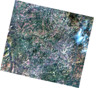
BEFORE CORRECTION AFTER CORRECTION
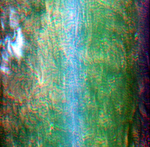
Not only is each camera unique, but because cameras have their own physical characteristics, these characteristic also changes over time as the sensor ages. The detector is also sensitive to temperature changes, which SmallSats can’t regulate very well yet.
Satellite image products need to show the target area as if acquired from straight above, with a consistent representation of distances. Looking at the area at an angle, elevation changes such as mountains and valleys, and even the curvature of the earth, need to be accounted for to produce a product.
To be able to compare one image with another, the products need to be projected onto a standard grid and formatted into industry standard products. These products are geo-coded and contain metadata so that downstream users can use the imagery correctly and within context.
We hope you enjoyed reading our blog. We believe that it is important for users to have access to quality images, which is why we created our product FarEarth for SmallSats. Click here to give it a try!